I could spend all day exploring the great things to do with maps in the classroom. Between Google Earth and My Maps, there are so many ways to explore the earth and connect it to content in the classroom. As I prepare to teach a class on this for staff, I got lost in the many games that are now available for kids to just have fun with maps. What is really great is that they work on a Chromebook making it something that kids can do on their own devices.
SmartyPins is a marriage of trivia and maps that is wrapped up in a fun game for kids. You begin by selecting a category (arts and culture, science and geography, sports and games, entertainment or history and current events). You are given 1,000 miles certain number of miles of which you can lose for inaccurate answers or gain for fast answers. Areas currently covered are the U.S., U.K., Australia and Canda.
Another equally fun but more interactive map exploring game for kids is called Geoguesser. This web-based game can be played in single player or challenge mode. You are dropped in a street view map and you have to guess where you are. You can move around the location, spin the view to explore and use clues to explore. You gain points while trying to guess 5 different locations. Additional games for various continents and topics are also available. Learn about the location while experiencing real street views! So much fun!
Google Earth Tour Builder, while not a new tool is one that came to mind after sharing yesterday's post about the resource myHistro. Both tools are similar and make use of maps and visuals. Google Tour Builder combines Google Earth and a slideshow in which you can incorporate images, videos and text to connect locations all across the globe to tell a story. While the first thought that comes to mind might be history, there are plenty other ideas for use including biographies, tours of locations, field trip summaries and literature studies.
Google Tour Builder is a tool that requires a computer (not a Chromebook or iPad). On the computer it does require the Google Earth Plugin.
Creating a Tour is not challenging! Check it out!
1. Begin at www.tourbuilder.withgoogle.com. Sign in to your Google Account and click "Create New Tour".
2. Complete the "let's get started" page.
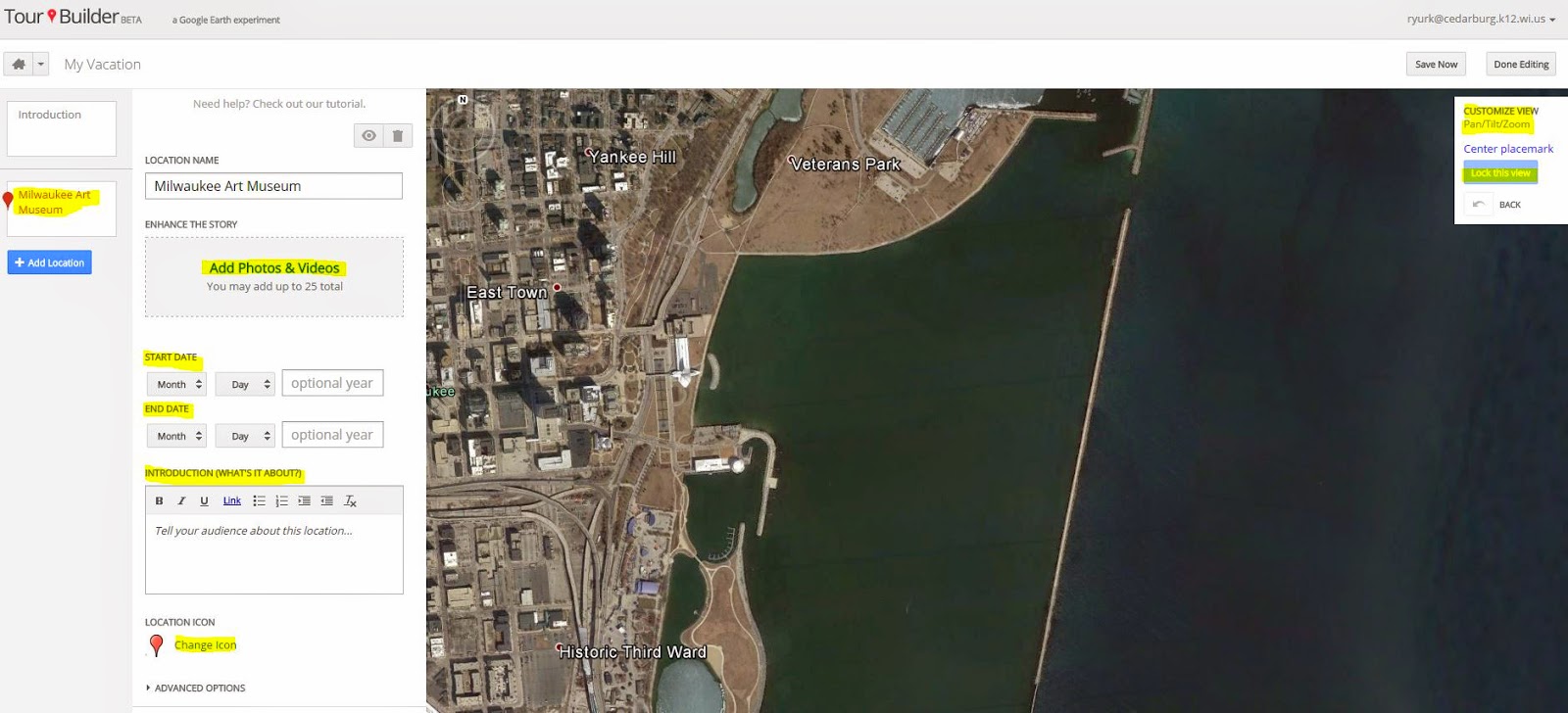
3. The Next page is where you begin to introduce you Tour. Complete the highlighted items and use the available tools to manage the view.
4. Click add a location on the left side panel 5. Type your location into the search or drop a placemark in a location you see on the map. Click "add to tour".
6. Once you Add to tour you then open a window in which you can personalize this location. You can add up to 25 photos and videos, dates, a story about the location, and even change the icon that represents the location on the map. One area not to neglect is the Pan/Tilt/and Zoom of the view in which the location on the map is viewed. Once you have it set, don't forget to "lock the view".
7. Continue to add your locations and they will build on the tour timeline on the left. Once you are done, click "Save Now".
8. Then, just as you would share another Google Doc, you will see a "share" button in the top right hand corner. Click on the share button and change the visibility to your desired settings. Click "done" and you have created your first tour!
If this step-by-step does not help you out, give this tutorial a try!
Google Maps are not just for getting around when you don't know your way...
Google offers some great ways to make use of maps in the classroom. They offer tutorials and resources for all types of map use. From beginning tutorials to more complex, there is a lot to consider. One thing is for certain, this is a resource I wish I saw more use of in the classroom.
Here are a few ideas that I found as I did some exploring:
Google Earth - Allows students to interact with and explore the world in ways unique to the computer experience. While we would all love to head out to Rome and see the history and artifacts there, Google Earth uses imagery that allows kids to travel back in time and view different locations to see how they have changed. with resources that show ideas such as they US Presidents or the trail of Lewis and Clark, this resource will add amazing depth to your units of study. Explore 3D imagery of locations such as Mars in Google Earth or the landing sites of the moon. Students can make use of Real World Math and other lesson plans that use Google Earth to learn new skills. Additionally, Using Tours you can create and play tours of places and content. Tours are a "flying" Google Earth experience in which students will be able to view terrain, maps and navigate using 3D images and even audio. So much to explore.
Google Maps - One of the many resources that Google provides to users is the Google Map. There are many ways in which you can use Google Maps each allowing for different ideas within the classroom. One of my favorite ways to make use of Maps is to use Maps Engine to build your own map. The tool allows you to draw on a map, enter and visualize data, add layers and set specific points for various resources. An easy to follow tutorial can be found here.
SumoPaint is a great drawing tool with advanced features is is hard to believe that it is free. The above graphic was created using SumoPaint in a manner of minutes! This online resource does not require any log in, email and allows you to save your drawing in jpg or png formats. What makes this an exciting classroom tool besides the above mentioned features, is that this tool allows you to begin a drawing with an image that you upload from your computer. So, what if students were to upload and label a map, an image to label or something to add information learned to? Students have so many creative elements we often do not tap into and this might be a way to reach some of them. Could students design a class, team or personal logo? The possibilities are endless with such a great tool.
Scribble Maps is a great resource for those working with geographical information within the curriculum. This tool uses Google Maps and allows you to annotate or scribble over the map to demonstrate geographical information, routes, or other information. Below you will find the first of many tutorials on the use of Scribble Maps. This one is the introductory video. It covers the basic information you need to know to annotate over a map of your choice, save, return to a saved map, or share a map with others. I can think of countless ideas on how you might incorporate Scribble Maps into the classroom. Here are just a few:
Have students keep a map of the travels of a character in a story and note the events occurring in each location.
Map major events in history on a world map for a specific day in history.
Follow the travels of an important event in history (Oregon Trail).
Have students demonstrate on a map the travels of their family.
Buddy with other classes across the country using Google Hangouts and send each class your map and password so that they can mark their location on the map.
Map current events of the week/month as they are discussed in class.
Scribble Maps can be embedded in a class blog allowing each student to be assigned a state or region of which to annotate and share on the class blog.
Follow a famous voyage such as Christopher Columbus.